


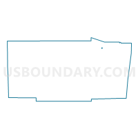
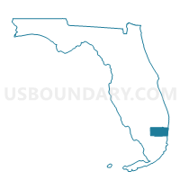
E018A-Voting District, Broward County, Florida
About
Outline

Summary
| Unique Area Identifier | 551358 |
| Name | E018A-Voting District |
| County | Broward County |
| State | Florida |
| Area (square miles) | 0.06 |
| Land Area (square miles) | 0.06 |
| Water Area (square miles) | 0.00 |
| % of Land Area | 100.00 |
| % of Water Area | 0.00 |
| Latitude of the Internal Point | 26.29012490 |
| Longtitude of the Internal Point | -80.22072920 |
Maps

Graphs
Select a template below for downloading or customizing gragh for E018A-Voting District, Broward County, Florida


Neighbors
Neighoring Voting District (by Name) Neighboring Voting District on the Map
- E018-Voting District, Broward County, FL
- E024-Voting District, Broward County, FL
- Q043-Voting District, Broward County, FL
Top 10 Neighboring County Subdivision (by Population) Neighboring County Subdivision on the Map
- Coral Springs-Margate CCD, Broward County, FL (217,025)
- Deerfield Beach CCD, Broward County, FL (173,967)